Researching Canadian Soldiers of the First World War
Part 9: Matching Battlefield Locations to the Modern Map
By Michael O'Leary; The Regimental Rogue
Introduction
Finding location information in soldier's letters, unit war diaries and other sources and then matching them to wartime maps can be an exciting part of researching an ancestor. Doing so helps you visualize the ground he travelled and fought over and can add rich context to descriptive narratives produced by a researcher for other family members or friends.
But the knowledge gained from matching those wartime details of battlefield location to maps can be taken further. To see those locations today, whether it be through Google Maps, Google Earth or other online resources, or to visit them in person, it is necessary to match those maps to the modern world. While many well-known historic battlegrounds have been preserved in one extent or another, such as the Plains of Abraham and Gettysburg, much of the battlefields of the First World War could not be so maintained. While some areas are protected as memorials, many others have been restored to use as farmlands, built over in restored or new urbanization or other uses. Even so, it is possible to locate past events on this reshaped terrain and re-establish connections not only to the actions of out ancestors, but also to see what changes have been wrought by the resilience and progress of society over the 90+ years since the Great War
In Part 7 of this series of articles, we identified and located "Ontario Trench" on a July 1917 trench map at the McMaster University map collection of World War I Military maps & Aerial Photography. Comtinuing to work with that particular map, this article will introduce a process to match that piece of ground to the online mapping of the modern world using Google Maps. These are by no means the only resources available to you, and you may already be comfortable using alternative sources, but they will serve our purposes for this demonstration.
Step 1: Examining the period map.
The process in Part 7: Deciphering Battlefield Location Information left us examining a rather small portion of a First World War battlefield map (commonly called a "trench map" although this term is rather inaccurate except for those with the trench overlays printed on them). That small piece of terrain may not include any significant identifying features that will help us match it to the modern world without more information. So, we begin by zooming our view outward, even to examining the full map sheet once again for geographical signposts to help us find the area once again on a modern presentation.
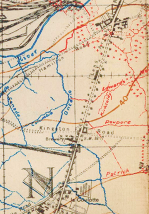
On the full map sheet, "36c SW; Lens", we can identify nearby towns and cities, noting the proximity of these places to our area of interest. In this example, we can see that Ontario Trench lies due west of the (1917) centre of Avion and south of the area named Eleu dit Leauvette. Using these as our clues to orienting ourselves on the modern map of France,we can turn to Google maps and find Avion to begin with.
As we do so, we have to keep a few things in mind:
- Place name spelling can change, so direct map searches on old names may be inconsistent for results. Search on larger place names first.
- As you zoom in on an electronic map, there are levels where the names of general locations will switch to the naming of individual highways and streets, this will change the information available to guide your search at those levels.
- The best results will be discovered in working from the largest "markers" to successively smaller ones until you have isolated a likely area.
Working from named areas such as towns and villages, you should be able to narrow your search area to a relatively small section of countryside. From there, a more detailed study will be out next step
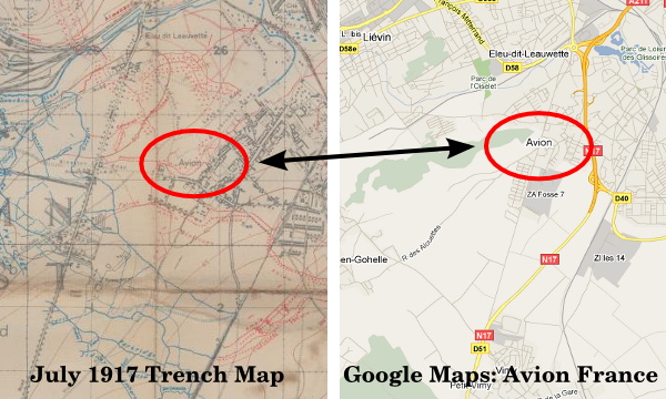
The general area of Ontario Trench shown on the July 1917 1:20,000 trench map ( McMaster University World War I Military maps & Aerial Photography) and the current Google Maps view. Both views have been expanded to include the closest identified town (Avion, red circled in each image)
Step 2: Matching the period map to a general view of the modern terrain.
Once you have used the general "markers" to identify the section of town, village or countryside of interest, it is necessary to use the maps to make a closer study of terrain features to narrow our region of interest. As you do so, keep the following in mind:
- As towns have grown over the past 90 years, the central locating point assigned by electronic mapping may have shifted from the original reference map we are using. Relative locations of towns may appear to have shifted because of the uneven growth of urban areas.
- The newest generation of major highways will often not follow any older routes on the wartime maps.
- The more direct routes between town on the wartime maps will usually also be found on the modern maps and still be principal routes, though not necessarily the modern high speed routes, between those towns.
But, even with those limitations, careful study will draw out consistent similarities between your maps, and the persistent features will become apparent.
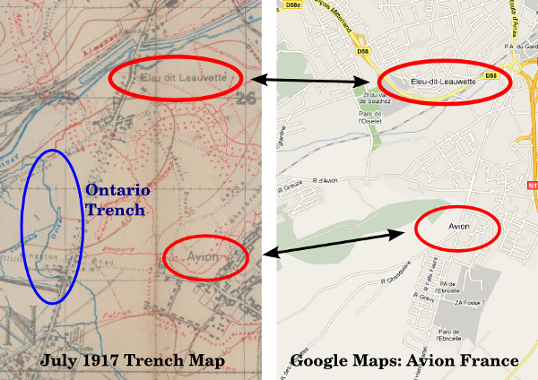
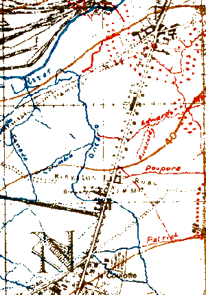
In this view both maps have been "zoomed in" to show the named locations near the Ontario Trench location. Note the change in spelling of Eleu dit Leauvette (1917) to Eleu-dit-Leauwette (current map). Close examination will also show that the location of the names on each map have moved eastward, so that although the named appear to be positioned approximately the same, they are not in relation to the Ontario Trench site.
Step 3: Finding common features.
As the named towns and major features allow for closer examination and comparison of the wartime and modern maps, it is then necessary to watch for physical details that will aid in matching terrain.
- Many minor roads, buildings, etc., found on the wartime trench maps may have disappeared, being relocated and built over in the 90+ years since the war.
- Water courses of moderate size may have moved through natural processes, or where irrigation canals, levees and other water management features have been rebuilt over the intervening decades.
- Smaller watercourses may have disappeared as greater control of watersheds have taken effect or where minor flows have been diverted into man made drainage systems.
- Few buildings in the old front lines areas and marked on wartime maps will have survived post-war reconstruction, but some major or historic structures might still be found.
Despite the list of features that may have disappeared, it should still be possible to match nearly any battlefield area to the appropriate modern map. When multiple features, roads, rivers, etc., can be found that align well between the maps, the probability increases that you have the right spot.
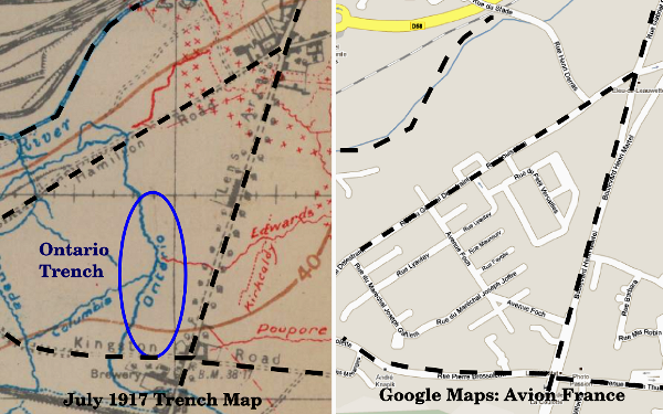
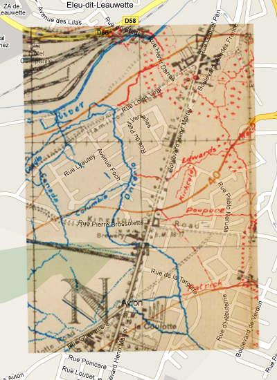
Zoomed in further to focus on the Ontario Trench area, the location of simlar road patterns and the course of the river in the upper left are iutlined to show the matching sites.
A significant benefit of using Google maps or another online mapping program is the ability to switch between map and satellite views. The satellite view allows a detailed examination of the area's ground and vegetation, helping a researcher to build a better picture of the type of terrain over which their ancestor travelled or fought.
Step 4: Making and overlaying a transparency.
With the battlefield map matched to the modern terrain, a further step might be taken to produce an even more accurate picture of the trench lines on the modern map or air photo. This involves making a transparent version of the battlefield map and overlaying it on top of the modern map or air photo.
This will require some skills with an advanced photo editing program, such as Photoshop or GIMP, the latter having the advantage of being a free program. While neither of these are intuitive to learn, they can produce very good results for building graphic additions to your research.
In brief, the following outlines the stages of producing an overlay, save copies under new names at each stage so that you only have to restart the process at your last successful step if you make a error:
- Take screenshot captures of the relevant areas of the battlefield trench map and the Google map.
- Crop each captured image to the area of interest, as best as possible match the map scale (i.e., area covered) and the image size of the two areas.
- Open the trench map image in your photo editing program.
- Adjust the brightness/contrast of the trench map image until the trench colours (red/blue) are bright and bold, and roads and other details remain legible, but the sepia background has faded to white.
- Change the now white background to a transparent setting.
- Open the modern map image.
- Create a new "layer."
- Copy and paste the transparent trench map element into the new layer of the modern map image.
- Depending on your experience with the photo editing program, the next stages will require some practice and some exploration to find the right features:
- Since the two maps will probably not be exact matches in scale, it is necessary to adjust the overlayed trench map element to match the terrain beneath it.
- Using scaling (resizing) and various transformation tools (rotation, perspective, etc.) adjust the shape and size of the overlay until your identified matching features coincide.
- Export and save your product.
The Ontario Trench area of the July 1917 Trench Map, the version on the right has been adjusted to make the background transparent.
The Ontario Trench area of the July 1917 Trench Map, overlayed on the current Google maps image of the corresponding map area.
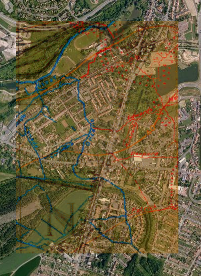
The Ontario Trench area of the July 1917 Trench Map, overlayed on the current Google maps image of the corresponding area of the satellite image.
I have deliberately kept these instructions brief. Differences between available photo editing programs, the varied backgrounds and experience of users and the possibility that even detailed instructions for a specific program will be made obsolete by a program update make offering more a futile gesture. I can only encourage you to experiment until you find a workable solution for yourself. Alternatively, a possibility for family researchers is to dragoon a younger family member into helping with this task, it may even lead to their own increased interest in the research project as a shared effort.
Researching Canadian Soldiers of the First World War
- Introduction
- Part 1: Find your Man (or Woman)
- Part 2: The Service Record
- Part 3: Court Martial Records
- Part 4: War Diaries and Unit Histories
- Part 5: Casualties
- Part 6: Researching Honours and Awards
- Part 7: Deciphering Battlefield Location Information
- Part 8: More Mapping Information
- Part 9: Matching Battlefield Locations to the Modern Map
- Part 10: Service Numbers; More than meets the eye
- Part 11: Rank, no simple progression
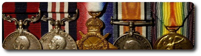
- Part 12: Medals; Pip, Squeak, Wilfred and the whole gang
- Part 13: Evacuation to Hospital
- Part 14: The Wounded and Sick
- Part 15: Crime …
- Part 16: … and Punishment
- Part 17: Battalions and Brigades, Companies and Corps
- Part 18: Photo Forensics: Badges and Patches
- Part 19: Veterans Death Cards
- Part 20: The Vimy Pilgrims (1936)

- The O'Leary Collection; Medals of The Royal Canadian Regiment.
- Researching Canadian Soldiers of the First World War
- Researching The Royal Canadian Regiment
- The RCR in the First World War
- Badges of The RCR
- The Senior Subaltern
- The Minute Book
- Rogue Papers
- Tactical Primers
- The Regimental Library
- Battle Honours
- Perpetuation of the CEF
- A Miscellany
- Quotes
- The Frontenac Times
- Site Map
QUICK LINKS
- Tomb of the Unknown Soldier
- Vimy Memorial
- Dieppe Cemetery
- Perpetuation of CEF Units
- Researching Military Records
- Recommended Reading
- The Frontenac Times
- RCR Cap Badge (unique)
- Boer War Battles
- In Praise of Infantry
- Naval Toast of the Day
- Toasts in the Army (1956)
- Duties of the CSM and CQMS (1942)
- The "Man-in-the-Dark" Theory of Infantry Tactics and the "Expanding Torrent" System of Attack
- The Soldier's Pillar of Fire by Night; The Need for a Framework of Tactics (1921)
- Section Leading; A Guide for the Training of Non-Commissioned Officers as Commanders and Rifle Sections, 1928 (PDF)
- The Training of the Infantry Soldier (1929)
- Modern Infantry Discipline (1934)
- A Defence of Close-Order Drill (1934): A Reply To "Modern Infantry Discipline"
- Tactical Training in the British Army (1901)
- The Promotion and Examination of Army Officers (1903)
- Discipline and Personality (1925)
- The Necessity of Cultivating Brigade Spirit in Peace Time (1927)
- The Human Element In War (1927)
- The Human Element In Tanks (1927)
- Morale And Leadership (1929)
- The Sergeant-Major (1929)
- The Essence Of War (1930)
- Looks or Use? (1931)
- The Colours (1932)
- Personality in Leadership (1934)
- Origins of Some Military Terms (1935)
- Practical Examination; Promotion to Colonel N.P.A.M. (1936)
- Company Training (1937)
- Lament Of A Colonel's Lady (1938)
- Morale (1950)
- War Diaries—Good, Bad and Indifferent
- Catchwords – The Curse and the Cure (1953)
- Duelling in the Army
- Exercise DASH, A Jump Story (1954)
- The Man Who Wore Three Hats—DOUBLE ROLE
- Some Notes on Military Swords
- The Old Defence Quarterly (1960)
- Military History For All (1962)
- Notes for Visiting Generals (1963)
- Hints to General Staff Officers (1964)
- Notes for Young TEWTISTS (1966)
- THE P.B.I. (1970)
- Standing Orders for Army Brides (1973)
- The Time Safety Factor (1978)
- Raids (1933)
- Ludendorff on Clerking (1917)
- Pigeons in the Great War
- Canadian Officer Training Syllabus (1917)
- The Tragedy of the Last Bay (1927)
- The Trench Magazine (1928)
- Billets and Batman (1933)
- Some Notes on Shell Shock (1935)
- Wasted Time in Regimental Soldiering (1936)
- THE REGIMENT (1946)
- The Case for the Regimental System (1951)
- Regimental Tradition in the Infantry (1951)
- The Winter Clothing of British Troops in Canada, 1848-1849
- Notes On The Canadian Militia (1886)
- Re-Armament in the Dominions - Canada (1939)
- The Complete Kit of the Infantry Officer (1901)
- The Canadian Militia System (1901)
- The Infantry Militia Officer of To-day and His Problems (1926)
- Personality in Leadership (1934)
- British Regular Army in Canada
- Battle Honours (1957)
- Defence: The Great Canadian Fairy Tale (1972)
- The Pig (1986)
- Standing Orders for the Fortress of Halifax, N.S.; 1908
- Medals and Badges - Fakes and Copies
- Army Punishments Part 1 - • Part 2
• C.A.R.O. No. 6719 - Campaign Stars, Clasps, The Defence Medal and the War Medal 1939-45
[an error occurred while processing this directive]
[an error occurred while processing this directive]
[an error occurred while processing this directive]