Researching Canadian Soldiers of the First World War
Part 7: Deciphering Battlefield Location Information
By Michael O'Leary; The Regimental Rogue
Introduction
When researching the activities of an ancestor and his regiment in the First World War, one of the recurring stumbling blocks is often the difficulty of resolving information about locations. Not unlike today, wartime references to locations can range from the informal, such as soldiers' phonetically spelled interpretations of place names, to the formal, in the form of cryptic map reference. For anyone trying to trace these references, which can be mixed throughout the available references, it can be a frustrating and seemingly futile exercise.
But how does one delve deeper? When regimental histories, war diaries and other sources use a mixture of contemporary map references, trench names and vague references from these identified points, how does one match that information to the ground today?
Place Names
"Plug Street" – Ploegsteert
"Wipers" – Ypres
"White Sheet" – Wytschaete
"Pop" – Poperinghe
Examples of soldiers corrupting place names to more easily pronounced, and spelled, versions. Unravelling location data in First World War literature, diaries and letters can also be an education in the collective linguistic talents of a generation of front line troops.
Place names, either used as found, or once deciphered and translated from soldiers' argot into the proper place names, can be used for direct searches of online or hard copy maps. The level of detail to be found in online facilities such as Google Maps provides a excellent way to explore the terrain around named sites.
When researching locations, searches should be conducted for each of the various spellings that may appear in soldiers' letters and official documents. Not every transcription will have corrected place name spellings and links to further information may be found through any of the possible variations.
While place names can put your research effort into the right vicinity, they may not always provide enough detail in themselves to locate events precisely. For that, we will have to rely on further clues as they appear and the need to decypher the information our soldier ancestors left in the records they created.
Trench Names
Another common type of location information that may be found when researching a soldier of the First World War is named trenches or other features of the battlefield. "Regina Trench", "Chassery Crater", "Zollern Graben"; and many more names that would have required no further explanation regarding location, events or emotional significance to the many soldiers who fought there. For those of us following in their footsteps, however, we lack those shared memories they had from being there, and we need to fall back on other resources to complete our picture of the physical battlefield.
Many well-known named locations will appear in multiple sources and details of their locations can be gathered from them. Others are less commonly recorded and it may not be easy to find references to the name, or the right site with that name when a name may have been used more than once across the Western Front. Care must be taken that location details matched to a name fit with the larger picture of a soldier's or unit's movement on the battlefield. When a location seems out of context it probably is (remember that mobility and rates of movement are by the standards of 1914-1918, not comparable to what we might achieve in a modern word), and a further search for a more logical spot by the same name may produce other results.
There is one very useful reference work available to help with trench names. This volume, published in 2006, is available commercially and may also be available through inter-library loan:
Rats Alley: Trench Names of the Western Front 1914-1918 , by Peter Chasseaud, published by Spellmount Limited, 2006, ISBN 1-86227-276-X
Description (paraphrased from Amazon): "This book is the first ever study of the trench names of the Western front providing over 10,000 trench names complete with map references which reveal the full horror of trench warfare as well as throwing an extraordinary sidelight on the cultural life of the period and the landscape and battles of the Western Front. Covers all the major and minor battlefields, from Ypres, Loos, Vimy Ridge and Arras to the Somme, Cambrai and the 1918 battles. Includes the first ever gazetteer of over 10,000 trench names, complete with map references. Focuses on British trench naming policy and practice but also includes Australian, New Zealand, Canadian and Indian names and also chapters on French and German naming. A vital tool for military and family historians. "
Whether your research leads to gathering a large or small number of named trenches and other battlefield sites, Rats Alley will be an invaluable resource if you want to place events geographically. But if you have only have a few queries (i.e., countable on one hand), then you may find someone on the CEFSG or the Great War Forum to look them up for you after you have built a rapport with the members of the forum (participation does have its rewards). If you have a large number of queries, then purchase or library loan will be your best option.
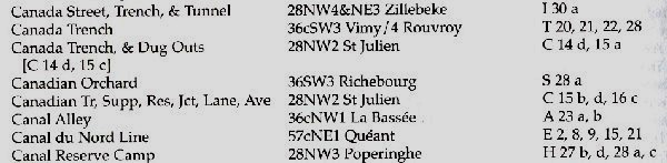
An excerpt from the gazetteer section of Rats Alley: Trench Names of the Western Front 1914-1918, by Peter Chasseaud
(NOTE: this excerpt has been reduced in size from its published version, and appears with less clarity than the high quality presentation in Rats Alley.)
Map References
Whether your location data comes from Rats Alley or another source, it will lead you to the next step in your location quest. The information in Rats Alley is presented in the form of a map sheet identification and the "Map Reference" for the spot. At first, this information may seem even more cryptic than the trench name was to being with, but it provides the necessary information to track down the right map, and to find the spot on the map you are looking for.
Let us say, for example that great-grandfather always told a story of enjoying a memorable feast of bully beef with good pals while his battalion occupied Ontario Trench. Consulting Rats Alley, we find that Ontario Trench is on map sheet 36cSW1 LENS, and that the Map Reference is N 25 c, 31 a (i.e., in map square N running from subordinate square 25c to 31a).
The McMaster University Map Collection
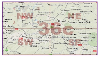
One very well organized website for First World War maps is the McMaster University map collection: World War I Military maps & Aerial Photography. This is an excellent place to start as it includes an index page showing the relative locations of each map sheet. The image reproduced below is a screen capture from the McMaster site, and you will find that their presentation links each map sheet to the related map images they host.

From the McMaster University First World War map collection website, this map graphic shows the relative position of the mapsheets covering the Western Front in northern France and Belgium.
Working in McMaster's collection of 1:5,000 and 1:40,000 scale maps, we can easily see by the above diagram that map sheet 36C includes Vimy. Clicking that square on the McMaster page brings us to their collection of map images for sheet 36C. That page includes the following graphic for further orientation:
From the McMaster University First World War map collection website, this map graphic shows the relative position of the mapsheets covering the Western Front in northern France and Belgium.
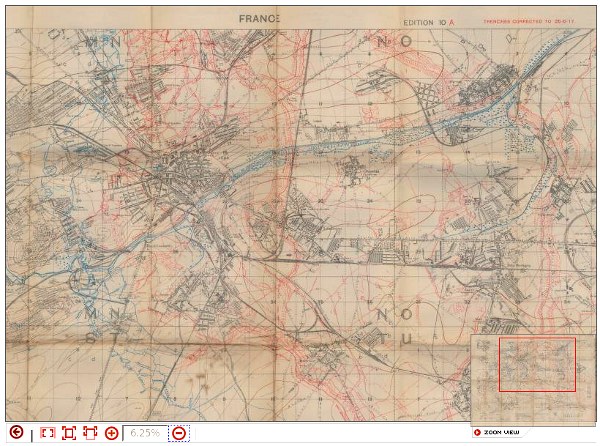
This images shows us the relative location of the "SW" (or south-west) portion of the 36C map sheet. From there we scroll down the table of displayed maps and links to find (among others) "36c SW; Lens". The offered map was printed in July 1917 and is at a scale of 1:20,000.
Opening the right hand map link in the table takes us to the details for that map and then to McMaster University's viewing utility where we can zoom in on the map sheet. Now that we have the correct map sheet, we are looking to resolve the locations for the remainder of the reference given in Rats Alley: N 25 c, 31 a. Zooming in we can find the map square "N" in the top centre of the sheet.
From the McMaster University First World War map collection website, this map graphic shows a section of mapsheet 36c, with the complete map square "N" in the centre bordering on the top margin. Note the upper and lower corners of map square "N:, where the subordinate squares of neighbouring map squares are labelled for the adjoning squares.
Examination of the map square "N" shows the numbered subordinate squares, and a glance at the upper right subordinate square shows the relative locations of the divisions "a", "b", "c" and "d". So, seeking subordinate squares "25" and "31" within map square "N", we can look for the divisions of each for the start and end of Ontario Trench.
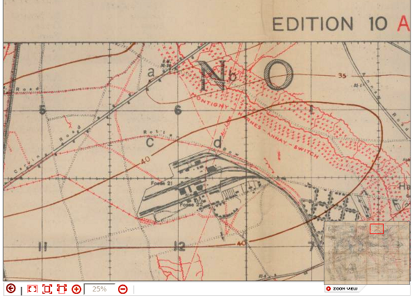
From the McMaster University First World War map collection website, this map graphic shows a close up image of the upper left of map square "N." Note the labelling of the adjacent map squares and the labelling of the four quadrants (a, b, c, d) of the subordinate square numbered "6" (i.e., "36.c.N.6").
Zooming in on squares 25 and 31, we find Ontario Trench running roughly north to south from the southwest (i.e., "c") quandrant of square 25 to the north west (i.e., "a") quandrant of square 31.
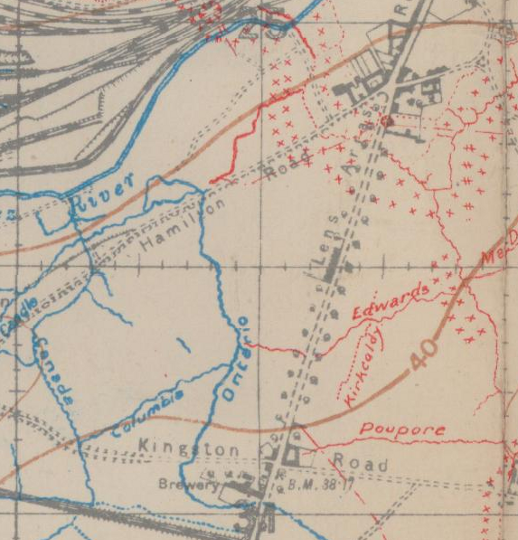
From the McMaster University First World War map collection website, this map graphic shows a close up of the lower half of squre N.25 and, below that, the top half of square N.31. As indicated by the map reference given for Ontario Trench (25.c to 31.a), we can see the labelled trench line in blue running throgh the centre of the image.
The preceeding example was chosen to lead from a named trench, through a reference included in Rats Alley to a map sheet with printed and named trenches. This process can be more difficult if:
- The named trench isn't listed in Rats Alley, in which case other clues may be necessary to get to the right map.
- The available maps do not have the trenchworks overprinted, in which case you will get to the right piece of terrain, but without the picture of the trench layouts.
- The available trench maps have a trench overlay, but not in the right area or the named trench isn't shown, this can happen because the same terrain may have been fought over repeatedly, trenches were destroyed and rebuilt, and it may take finding just the right edition printed about the same time as the events being researched.
- The scale of the available map may not have the level of detail necessary to include the named point being sought.
All of these reasons do not mean you have the wrong map sheet or location, they only mean you have not found a map for the exact timeframe for your research.
The map reference we used above "36C.N.25.a" brought us to a certain degree of resolution. Many times when map references were documented, such as for formal orders saved in the War Diaries, the map reference may include additional numbers, such as "36C.N.25.a.80.60". These following digits, in pairs, may be either single digits or double digits. They detail the specific location, in tenths and hundredths, within the subordinate square "c".
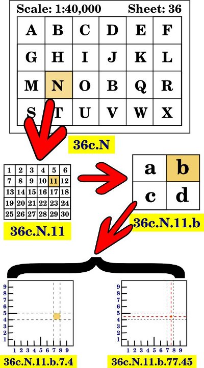
This diagram shows the progression from map sheet to the most exact elements of a map reference - "Sheet 36, map reference N.11.b.77.45".
These instructions will guide a beginning researcher to locating the location and map references found in service records, war diaries and other documents and locating them on the period maps of the First World War. To take your research a step further, especially for those who wish to trace an ancestor's footsteps across the battlefields of France and Belgium, it is necessary to find a way to match these locations to the modern world.
More Trench Map Sources
The McMaster University trench map archive described above provides an excellent resource when working online. Sometimes that is not possible or the most efficient option. In such cases a standalone capability may be desired and the following may be worth investigating:
National Archives British Trench Map Atlas, The Western Front 1914-18 - 1:10,000 regular series with an index of over 20,000 trench and topographical names and a commentary for each map:
"700+ trench maps from the collection held at The National Archives • Unique searchable index to trench names, hyperlinked to map(s) • Significant places of interest also hyperlinked • Historical and cartographical commentary • Edited by Dr Peter Chasseaud • Full technical support available • Large scale 1:10,000 • Zoom in for detailed analysis • All maps fully printable • Microsoft Vista and XP compatible • Covers the whole length of the British sector of the Western Front • Robust and easy to use interface • The new benchmark in mapping the Front • Early Bird offer available • Bristling with "can't-get-elsewhere" features • Invaluable resource for tour guides www.britishtrenchmaps.com"
Researching Canadian Soldiers of the First World War
- Introduction
- Part 1: Find your Man (or Woman)
- Part 2: The Service Record
- Part 3: Court Martial Records
- Part 4: War Diaries and Unit Histories
- Part 5: Casualties
- Part 6: Researching Honours and Awards
- Part 7: Deciphering Battlefield Location Information
- Part 8: More Mapping Information
- Part 9: Matching Battlefield Locations to the Modern Map
- Part 10: Service Numbers; More than meets the eye
- Part 11: Rank, no simple progression
- Part 12: Medals; Pip, Squeak, Wilfred and the whole gang
- Part 13: Evacuation to Hospital
- Part 14: The Wounded and Sick
- Part 15: Crime …
- Part 16: … and Punishment
- Part 17: Battalions and Brigades, Companies and Corps
- Part 18: Photo Forensics: Badges and Patches
- Part 19: Veterans Death Cards
- Part 20: The Vimy Pilgrims (1936)

- The O'Leary Collection; Medals of The Royal Canadian Regiment.
- Researching Canadian Soldiers of the First World War
- Researching The Royal Canadian Regiment
- The RCR in the First World War
- Badges of The RCR
- The Senior Subaltern
- The Minute Book
- Rogue Papers
- Tactical Primers
- The Regimental Library
- Battle Honours
- Perpetuation of the CEF
- A Miscellany
- Quotes
- The Frontenac Times
- Site Map
QUICK LINKS
- Tomb of the Unknown Soldier
- Vimy Memorial
- Dieppe Cemetery
- Perpetuation of CEF Units
- Researching Military Records
- Recommended Reading
- The Frontenac Times
- RCR Cap Badge (unique)
- Boer War Battles
- In Praise of Infantry
- Naval Toast of the Day
- Toasts in the Army (1956)
- Duties of the CSM and CQMS (1942)
- The "Man-in-the-Dark" Theory of Infantry Tactics and the "Expanding Torrent" System of Attack
- The Soldier's Pillar of Fire by Night; The Need for a Framework of Tactics (1921)
- Section Leading; A Guide for the Training of Non-Commissioned Officers as Commanders and Rifle Sections, 1928 (PDF)
- The Training of the Infantry Soldier (1929)
- Modern Infantry Discipline (1934)
- A Defence of Close-Order Drill (1934): A Reply To "Modern Infantry Discipline"
- Tactical Training in the British Army (1901)
- The Promotion and Examination of Army Officers (1903)
- Discipline and Personality (1925)
- The Necessity of Cultivating Brigade Spirit in Peace Time (1927)
- The Human Element In War (1927)
- The Human Element In Tanks (1927)
- Morale And Leadership (1929)
- The Sergeant-Major (1929)
- The Essence Of War (1930)
- Looks or Use? (1931)
- The Colours (1932)
- Personality in Leadership (1934)
- Origins of Some Military Terms (1935)
- Practical Examination; Promotion to Colonel N.P.A.M. (1936)
- Company Training (1937)
- Lament Of A Colonel's Lady (1938)
- Morale (1950)
- War Diaries—Good, Bad and Indifferent
- Catchwords – The Curse and the Cure (1953)
- Duelling in the Army
- Exercise DASH, A Jump Story (1954)
- The Man Who Wore Three Hats—DOUBLE ROLE
- Some Notes on Military Swords
- The Old Defence Quarterly (1960)
- Military History For All (1962)
- Notes for Visiting Generals (1963)
- Hints to General Staff Officers (1964)
- Notes for Young TEWTISTS (1966)
- THE P.B.I. (1970)
- Standing Orders for Army Brides (1973)
- The Time Safety Factor (1978)
- Raids (1933)
- Ludendorff on Clerking (1917)
- Pigeons in the Great War
- Canadian Officer Training Syllabus (1917)
- The Tragedy of the Last Bay (1927)
- The Trench Magazine (1928)
- Billets and Batman (1933)
- Some Notes on Shell Shock (1935)
- Wasted Time in Regimental Soldiering (1936)
- THE REGIMENT (1946)
- The Case for the Regimental System (1951)
- Regimental Tradition in the Infantry (1951)
- The Winter Clothing of British Troops in Canada, 1848-1849
- Notes On The Canadian Militia (1886)
- Re-Armament in the Dominions - Canada (1939)
- The Complete Kit of the Infantry Officer (1901)
- The Canadian Militia System (1901)
- The Infantry Militia Officer of To-day and His Problems (1926)
- Personality in Leadership (1934)
- British Regular Army in Canada
- Battle Honours (1957)
- Defence: The Great Canadian Fairy Tale (1972)
- The Pig (1986)
- Standing Orders for the Fortress of Halifax, N.S.; 1908
- Medals and Badges - Fakes and Copies
- Army Punishments Part 1 - • Part 2
• C.A.R.O. No. 6719 - Campaign Stars, Clasps, The Defence Medal and the War Medal 1939-45
[an error occurred while processing this directive]
[an error occurred while processing this directive]
[an error occurred while processing this directive]