Topic: Wolseley Barracks
Thanks to the University of Western Ontario, we can explore the development of London through their online publication of local aerial photos. Among their resources can be found a series of images taken of London's urban area in the 1950s, including the neighbourhoods covering and surrounding Wolseley Barracks.
Wolseley Barracks, created in 1886 on property formerly owned by the Carling family, saw the construction of Wolseley Hall between 1886 and 1888 and the occupation of the barracks by "D" Company of the Canadian Infantry School Corps in 1888. The Infantry School Corps has become The Royal Canadian Regiment, which had had a continuous presence in London since the 1880s and still recognizes Wolseley Barracks as its Home Station today. Today the 4th Battalion of the Regiment and The RCR Museum remain quartered in Wolseley Hall.
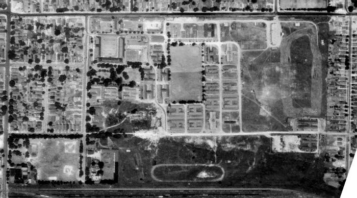
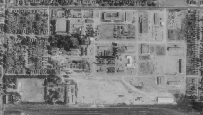
In these aerial photos taken in 1950 and 1955, we can see the development and growth of the buildings at Wolseley Barracks in the post Second World War decade. During the War, Wolseley Barracks was the home of No. 1 District Depot which saw Canadian servicemen at the start and the end of their service, passing through Wolseley Barracks for some of their training and then again for discharge. The RCR, which always maintained a foothold in Wolseley Barracks, returned in strength with a battalion of soldiers in 1952, necessitating the rebuilding of the base to replace the Second World War era hutments with new modern barracks, kitchen, headquarters and supporting services buildings.
1950

1955

The aerial photos at Western Libraries Map and Data Centre are provided with the following source data:
- City of London Aerial Photographs – 1950.
- Photography scale: 1:12,000 (red)
- Capture Date: July 3, 1950
- Source: Dept. of Planning & Dev.
- Photography scale: 1:10,000 (blue)
- Capture Date: June 4, 1950
- Source: National Air Photo Library
- City of London Aerial Photographs – 1955
- Photography scale: 1:15,700
- Capture Date: May to October, 1955
- Type: Black and White
- Size: 25 x 25 cm
- Source: Dept. of Lands and Forests
